Residents in Somerset are being urged to register to vote and check their Voter ID so they can have their say on who represents them in the Avon and Somerset Police and Crime Commissioner election.
The Police and Crime Commissioner (PCC) oversees your local police force and ensures they are prioritising what matters to you. The Avon and Somerset Police Area includes Bath & North East Somerset Council, Bristol City Council, North Somerset Council, Somerset Council and South Gloucestershire Council.
The notice of election was published on Monday 18 March and the nomination period for prospective candidates for the Avon and Somerset Police Crime Commissioner opened on Tuesday 19 March. Further details can be found on the website www.avonpccelection.org.uk
To vote, residents must be on the electoral register. With the deadline to register to vote fast approaching, Somerset Council is urging people who have not registered at their current address to make sure they are registered in time.
The deadline to register to vote is midnight on Tuesday 16 April. It takes just five minutes to apply online at www.gov.uk/register-to-vote. The deadline to apply for a postal vote is 5pm Wednesday 17 April.
Residents who are already registered to vote will have received their poll card in the post.
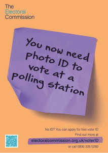
Electors voting in person at the polling station are now required to present an accepted photo ID before being issued with their ballot paper.
Those who are registered to vote at the polling station but do not have an accepted photo ID can apply for a Voter Authority Certificate before the deadline at 5pm on Wednesday 24 April. You can apply online via: https://www.gov.uk/apply-for-photo-id-voter-authority-certificate
Voters have a range of options for casting their vote – in person, by post or by appointing someone they trust to vote in their place, known as a proxy vote. The deadline to apply for a proxy vote is 5pm on Wednesday 24 April.
Will Godfrey, Police Area Returning Officer for the Avon and Somerset Police Area, said: “This election is an important opportunity to make your voice heard and have a say on who represents you on issues that directly affect day-to-day life here in Somerset. If you are not registered by 16 April, you won’t be able to vote. Voters will be required to take photo ID with them when they vote in person at the polling station.”
If you have recently turned 18 or moved home, it is particularly important that you act to ensure that you are registered to vote. If you were registered to vote in the last election and your details have not changed, you don’t need to take any action. If in doubt, you can check with your local authority on 0300 123 2224.
If you have any questions about Voter ID or would like to request a paper form to apply for the Voter Authority Certificate, contact 0300 123 2224 or elections@somerset.gov.uk.